홈/제품/Offline Map Maker

Offline Map Maker

v8.395 출시일: Nov 15, 2026 Windows 7 / 8 / 10 / 11

하나의 창에서 온라인 지도를 보고 필요한 타일을 다운로드하여 전체 지도를 PC에 보관하세요 — 이후 언제든 오프라인에서 둘러볼 수 있습니다.
Offline Map Maker
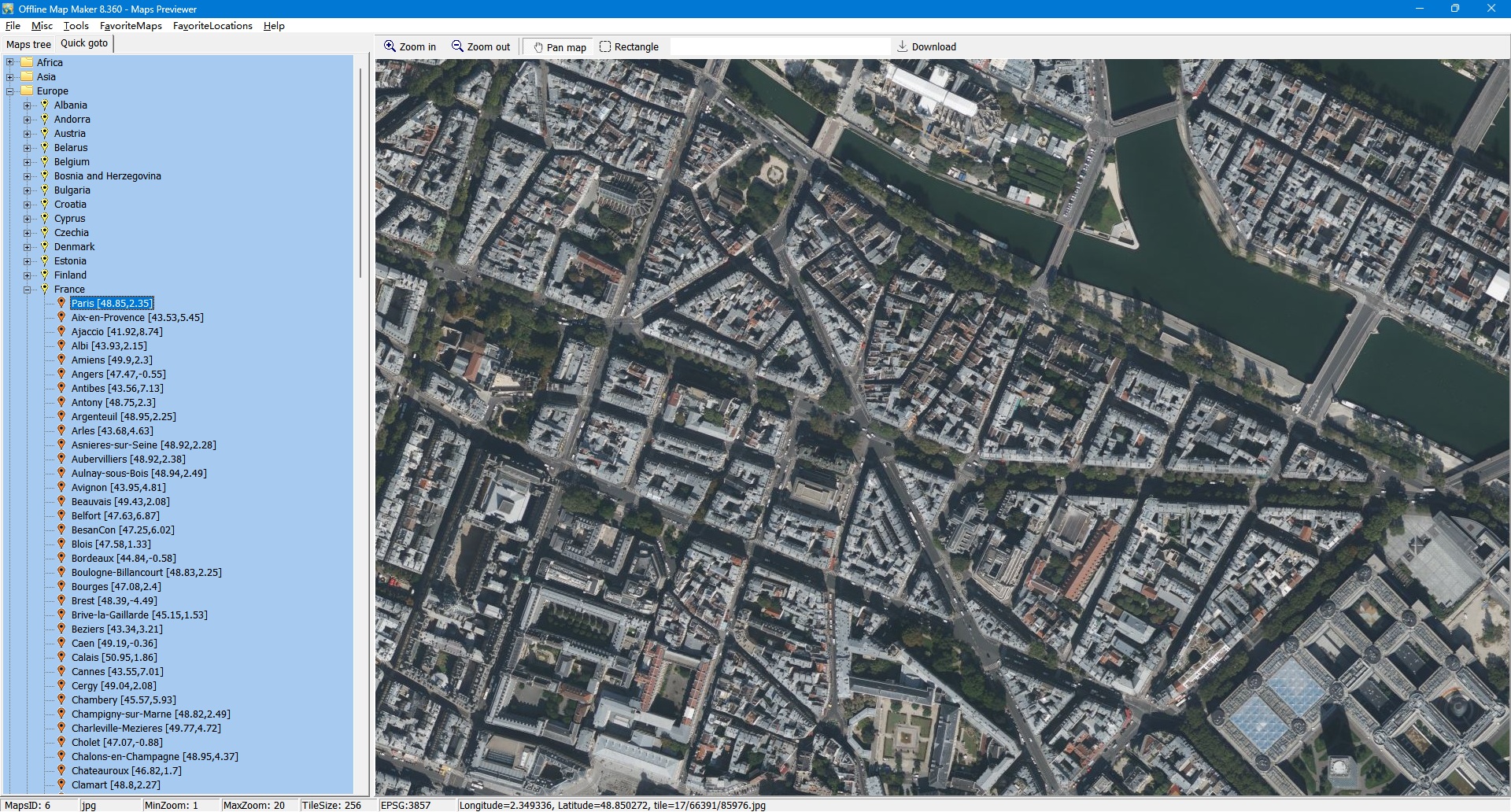
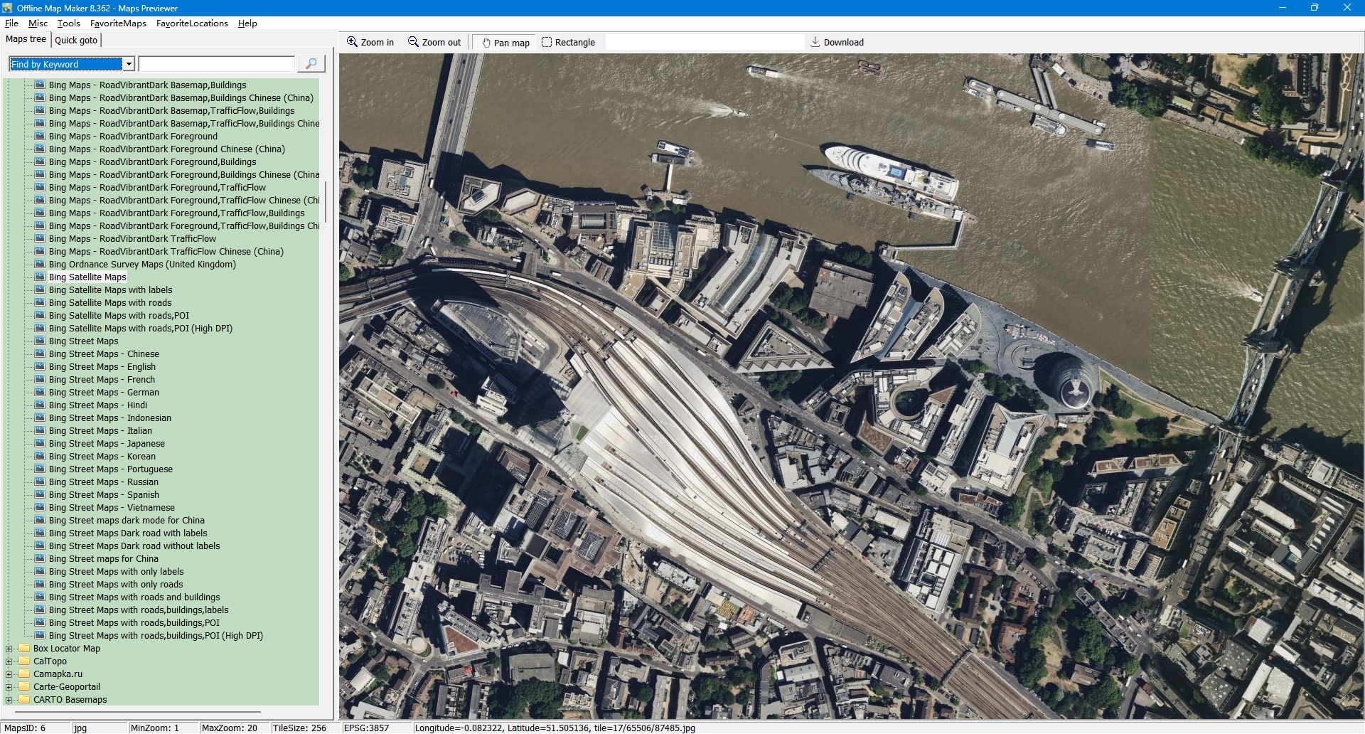
Offline Map Maker 지도 미리보기 창

Offline Map Maker - Maps Previewer

Offline Map Maker 하나의 통합 창에서 온라인 지도를 보고 다음으로부터 오프라인 지도 이미지를 받는 도구입니다: 지도 공급자, 다음을 포함합니다 5000개 이상의 지도 유형:

다운로드 후 오프라인 지도를 보는 방법은 여러 가지가 있습니다:

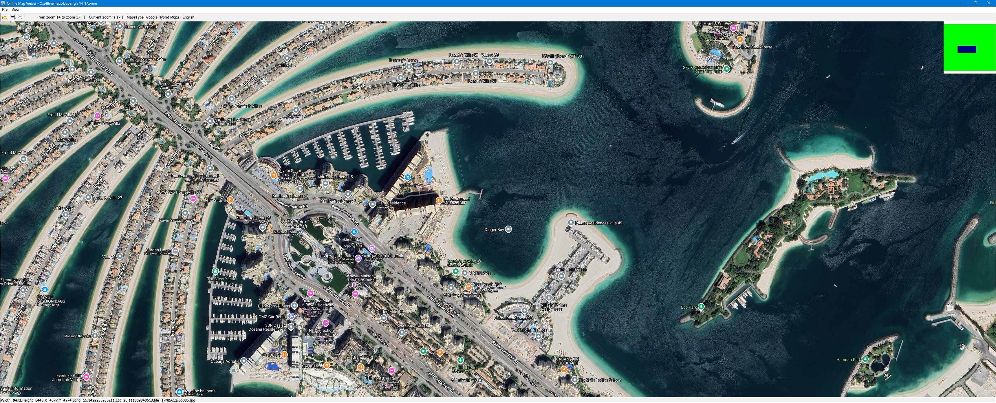
  • Offline Map Viewer로 다운로드한 오프라인 지도를 볼 수 있으며 오프라인 지도를 축소·확대할 수도 있습니다.
  • 오프라인 지도를 BMP,JPG,TIFF,PNG,SGI,IMG,RST,PNM,PDF,MBtiles,GPKG,WEBP,SQLITE,MRF,HDF,netCDF 파일로 출력합니다.
  • OziExplorer용 xxx.map 파일을 출력합니다.
  • Garmin 등에서 사용할 KMZ 파일을 출력합니다.
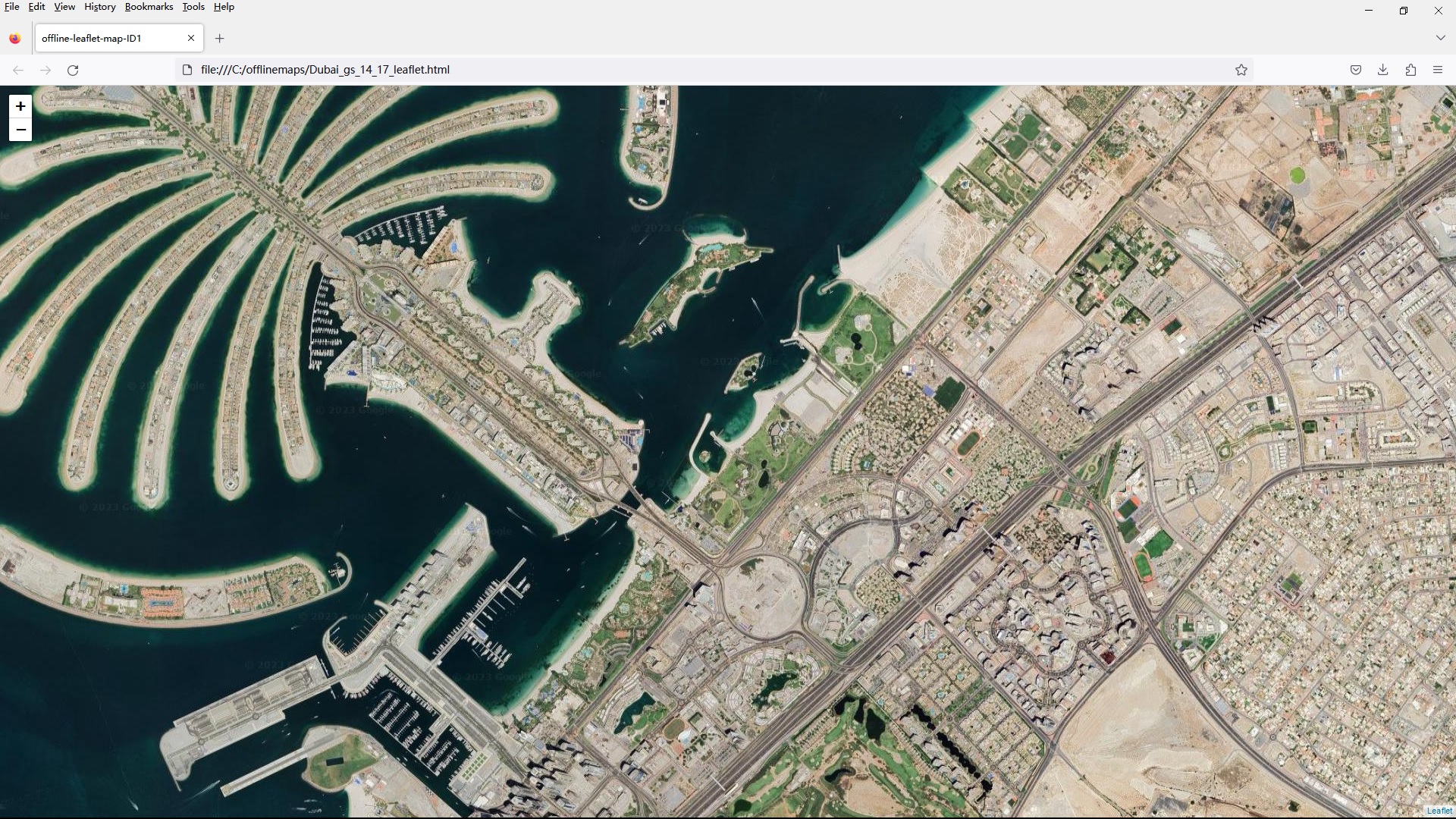
  • 일부 지도 유형의 경우 xxx.html 이름의 leaflet/openlayers/googleapi용 html 파일을 생성할 수 있습니다. 이 html 파일은 IE/FireFox/Chrome으로 열거나, 이를 활용해 웹 지도 서버를 구축할 수 있습니다. 모든 이미지와 html 파일을 Android 스마트폰이나 Windows 태블릿으로 복사하면 오프라인 지도를 볼 수 있습니다.
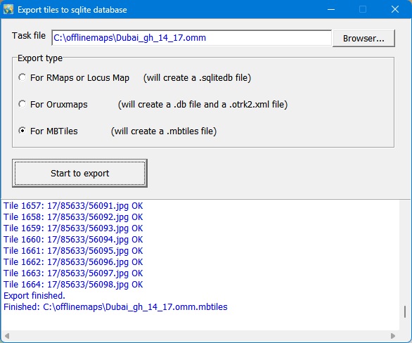
  • 모든 타일을 MBtiles 형식의 sqlite 데이터베이스로 내보낼 수도 있으며, MapBox, RMaps, Locus Map, Oruxmaps 등 Android나 iOS 앱에서 sqlite 데이터베이스를 사용할 수 있습니다.
  • mbtiles 파일을 만든 후 MBTiles Viewer로 이 파일을 볼 수 있습니다.

직접 도시나 관심 지역의 오프라인 지도를 만들고 싶다면 매우 유용합니다.

사용이 매우 쉽습니다. 사용 방법은 여기를 클릭하세요.

다운로드할 수 있는 지도 소스

Offline Map Maker는 다음 온라인 지도에서 작은 타일 이미지를 가져옵니다:

!Custom Map Type, Alpenkarte.eu, Amudanan.co.il (Israel), Apple Maps, Arcanum Maps, Arcgis Online, Arkansas GIS Offlice Map (USA), Atlas.harita.gov.tr (Turkey), Austrian Map, Baidu Map (China), Balad.ir, Basemap.at Karte (Austria), Basemap.de, BBBike Map Compare, Bergfex.at, BGMountains Online Maps (Bulgaria), Bhumi.atrbpn.go.id (Indonesia), Bhuvan-2D (India), Bing Maps, Box Locator Map, CalTopo, Camapka.ru, Carte-Geoportail, CARTO Basemaps, City of Cape Town (South Africa), CoCoRaHS Maps, Connecticut Environmental Conditions Online (USA), Cyberjapandata.gsi.go.jp, Cycle.travel, Cyclosm.org, Data.shom.fr, David Rumsey Historical Map Collection, Discover GIS Data NY (NewYork, USA), Ditu.so.com (China), Dituhui.com (China), Earth.jl1.cn, Eniro(kartor.eniro.se), EOX Maps, Esri Netherlands Content, FINN Kart, Freemap Slovakia, FY-3D Global Image, GAIA GPS Maps, Gaode Map (www.amap.com China), GeaMap.com, Geo.be Map, Geobru.irisnet.be (Belgium), Geofabrik OSM Inspector, Geogratis.gc.ca, Geokatalog.buergernetz.bz.it (Italy), Geoportail.wallonie.be, GeoPortal CGIS Qatar, Geoportal PH (Philippines), Geoportal Sachsenatlas (Germany), Geoportal.ancpi.ro (Romania), GeoPortal.MV, GEOportal.NRW, Geoportale Nazionale (Italy), Geoscience Australia, Geoviewer.sachsen.de, GEOVIS Earth (China), Getlost Maps Live (Australia), Gezgin.gov.tr, Gis.rchss.sinica.edu.tw, Gis3.nve.no, Gisro.donland.ru, GoMap.Az (Azerbaijan), Google Maps, GovMap Israel Maps, Gps.tile.openstreetmap.org, GraphHopper Maps, Here Maps, HGSS Cartography (Croatia), HiFleet, Hillshade - OpenStreetMap US Tileservice, ICGC Vissir3 (Catalunya, Spain), Icgc.cat, Ideihm.covam.es, Ign.es (Spain), Ign.gob.ar, Imagico.de maps, Isprambiente.it, Israel hiking map, Jawg Maps, Kakaomap - Daum Map (South Korea), Kanton Aargau (Switzerland), Kanton Solothurn (Switzerland), Kanton Zug (Switzerland), Kanton Zurich (Switzerland), Kartat.kapsi.fi (Finland), Kartbild.com, Karten von Attika, Kartogiraffe.de, Kartverket.no (Norway), Kompass.de, Kort-krak.dk, Kort.lmi.is (Iceland), Kortoverblik.dk, LA County (Los Angeles, USA), Lantmateriets Fjallkarta (Swedish), Light pollution map, Location SA Map Viewer (South Australia), Longdo Map (Thailand), Lvmgeoserver.lvm.lv (Latvia), MAA-AMET (Estonia), Make A Topographic Map (Canada), Map of cities of UAE - 2GIS, Map of Serbia, Map Warper - mapwarper.onki.fi, Map Warper - mapwarper.prov.vic.gov.au, Map Warper - warper.wmflabs.org, Map Warper - www.mapwarper.net, Map.geoportail.lu, Map.geoq.cn (China), Map.meta.ua, Map.turistautak.hu, Map.valentim.org (Portugal), MapAnt (Finland), Mapas.bogota.gov.co (Colombia), Mapbox, MapFan (Japan), maphub.cn, Mapion (Japan), Mappls (India), Mappy.com, MapQuest Map, Maps of Switzerland, Maps-for-free.com, Maps.eatlas.org.au (Australia), Maps.lt (Lithuania), Maps.nlsc.gov.tw, Maps.rlp.de, Maps.stamen.com, MapSite (NLS of Finland), Maptoolkit, Mapy.cz, Mapzs.pzs.si (Slovenia), Mesa County GIS Viewer (CO, USA), Mierune map (Japan), Min Karta (Sweden), MinView (Australia), Moovit, MOSCOWMAP (Russia), MTBmap.cz, MTBmap.no, MyGeoMap (Malaysia), Nakarte.me, Napr Maps (Georgia), NASA GIBS, National Library of Scotland (maps.nls.uk), National Map (Australia), Naver Map (South Korea), Navitel.Maps, New HK Maps, New Zealand Gazetteer, New Zealand Topographic Maps, Ngi.be (Belgium), NL Maps (Netherlands), Norgeskart (Norway), North Carolina Maps (USA), Norwegian Polar Institute, Nostra Map (Thailand), NSW Historical Imagery (Australia), NSW SIX Maps (Australia), NZ Topo Map, Omniscale, Onemap (Singapore), Online Maps for China, Open Data DC (USA), OpenAerialMap, OpenCycleMap.org, OpenFireMap, Openmaps.fr, OpenRailwayMap, OpenSeaMap, OpenSnowMap, OpenStreetMap, OpenStreetMap Foundation Japan, OpenStreetMap.FR (France), Orda.of.by, OSGeo.cn (China), OSM deutscher Stil, Osm.rrze.fau.de, Osm.rrze.fau.de HD, Osmand.net, Parselsorgu.tkgm.gov.tr (Turkey), PDOK Viewer (Netherland), Petal Maps, PhilaGeoHistory Maps (Philadelphia, PA, USA), PhoneMaps, Polska.geoportal2.pl (Poland), portal.csdi.gov.hk, Portland Maps (Portland, USA), Publictransportmap.org, QA Tools (qa.poole.ch), Queensland Globe (Australia), Reit-und Wanderkarte (Hiking and Trail Riding Maps), Retromap.ru, Roscosmos Geoportal, S2maps.eu, SafeCast Map, SanGIS - (San Diego, USA), ScanEx Web Geomixer, Scgis.net, Scottish Index of Multiple Deprivation, Search.ch map, Sedecatastro.gob.es (Spain), Sentinel Explorer, Sentinel-2 map, SePlan (Norway), Services.geodataonline.no, ShipDT, Shipxy.com, SIWEIearth, Skoterleder.org, Snowmobile routes and ruts in Finland (Kelkkareitit.fi), Solargis.com, Stadia Maps, Strava Global Heatmap, Supermap (China), Susudata.de - messtisch, Sverige karta, Swisstopo, Tencent Map (China), Terinfo.ujbuda.hu (Hungary), Terkep.torokbalint.hu (Hungary), TerraScope, Thailand maps, The National Map (USA), Thueringen Viewer, Thunderforest, Tianditu (China), Tianditu Beijing (China), Tianditu Guangdong (China), Tianditu Shanghai (China), TileServer GL, Top-o-Viewer, Topomapviewer.ngi.be, Topotijdreis.nl, Topotresc, Toronto Maps (Canada), Tracestrack, TuristickaMapa.sk, Turku.fi, TuttoCitta (Italy), UMP-PC.pl, Ut.no Kart, ViaMichelin, Vietbando Maps (Vietnam), Visicom Maps (Ukraine), Visor.gva.es, Vlaanderen.be (Belgium), Wanderservice-schwarzwald.de, Waymarkedtrails.org, Waze Livemap, Web_PowerLine_KedUR, Whereis Maps of Australia, Wikimapia, Wikimedia Maps, World Imagery Wayback, Yahoo Japan Maps, Yahoo Maps, Yandex Maps (Russia), Custom Map Styles of Bing Maps, Customized Google Maps, 등

실제 모습 보기

아래의 모든 스크린샷은 프로그램 자체에서 촬영한 것입니다. 이미지를 클릭하면 원본 크기로 열립니다.

Offline Map Maker 빠른 이동 대화상자

Offline Map Maker - Maps Previewer - Quick Goto

원본 크기로 보기
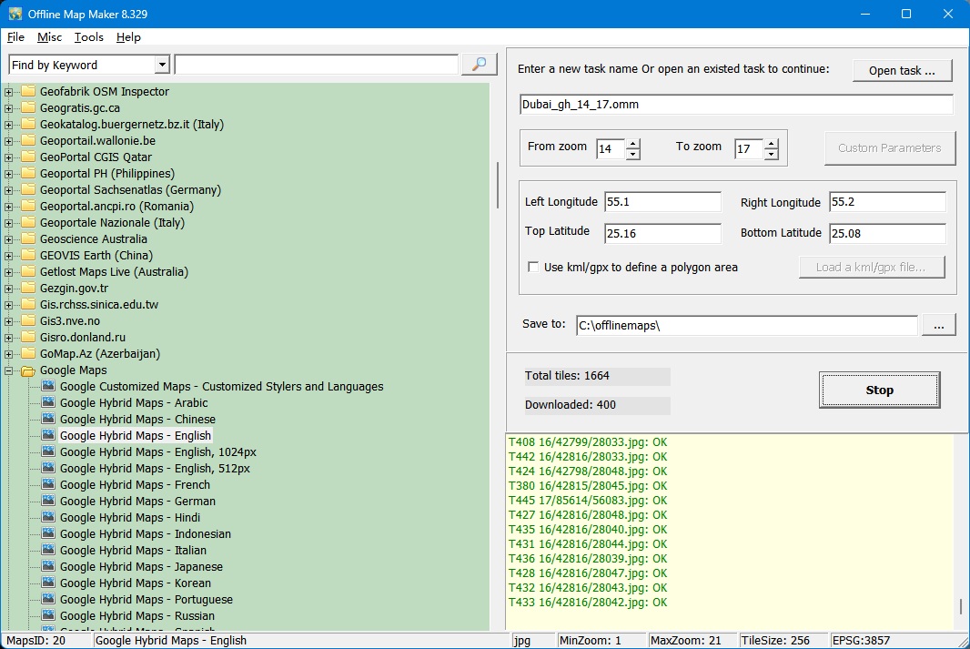
Offline Map Maker 지도 다운로더 창

Offline Map Maker - 지도 다운로더

원본 크기로 보기
클릭하면 큰 이미지로 볼 수 있습니다

Offline Map Viewer

원본 크기로 보기
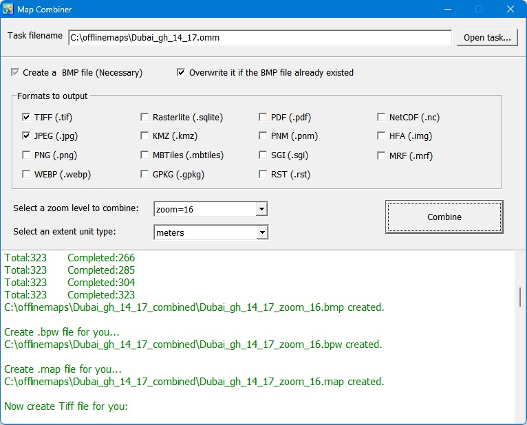
지도 컴바이너 창

Map Combiner

원본 크기로 보기
타일을 sqlite 데이터베이스로 내보내기

타일을 sqlite 데이터베이스로 내보내기

원본 크기로 보기
브라우저에서 열린 오프라인 지도

브라우저에서 지도 보기

원본 크기로 보기
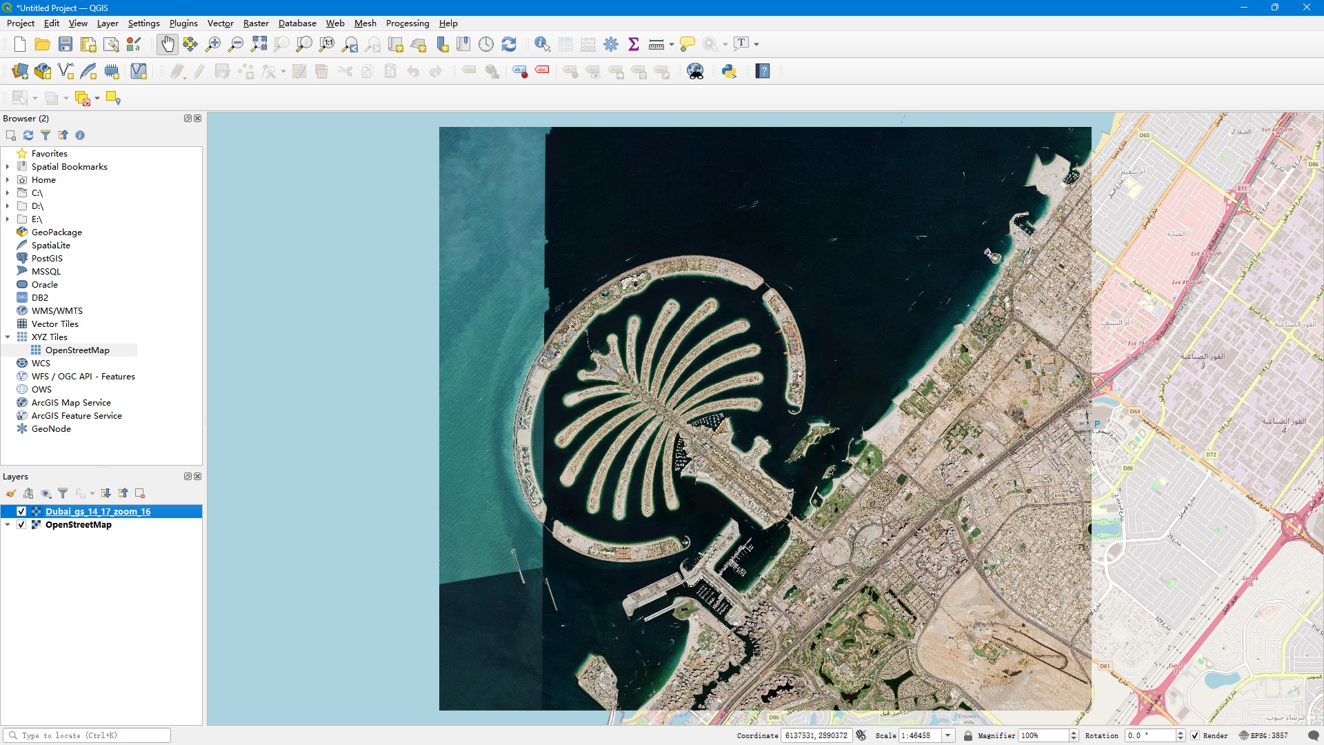
QGIS에서 레이어로 표시

QGIS에서 레이어로 표시된 병합된 TIFF 파일

원본 크기로 보기
일회성 결제 · 평생 라이선스
체험판 안내:체험판에서는 높은 줌 레벨의 이미지를 다운로드할 수 없습니다. 체험판의 최대 줌 레벨은 13입니다.

지원 이메일: omm@allmapsoft.com

구매 전 궁금한 점이 있나요? FAQ 읽기 또는 업데이트 기록 확인.